Ducks Unlimited Canada | Story / Boreal, Conservator, Science
September 19, 2022
Helicopters, satellites and wading in marshes lay the groundwork for conservation
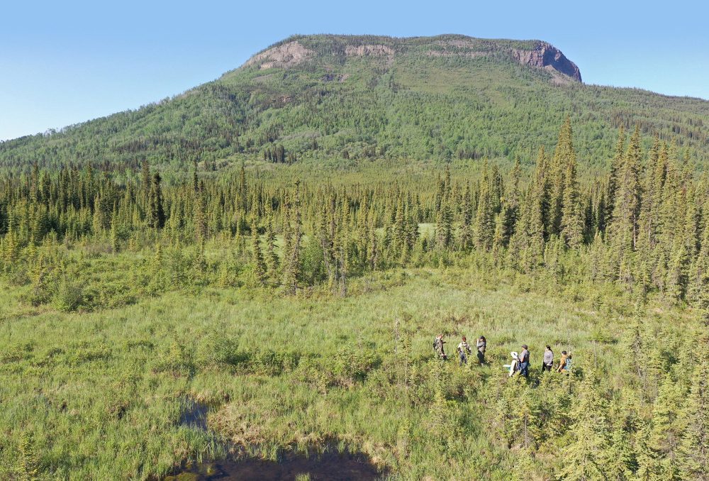
Ducks Unlimited Canada and Dane nan yé dāh Kaska Land Guardians surveying roadside wetlands. Photo © DUC
For two weeks this summer, remote sensing specialists from DUC’s national boreal program travelled by helicopter, mapping wetlands in and around one of the largest intact and pristine wilderness areas in northern British Columbia.
Dene K’éh Kusan, which means “always will be there” in Kaska, is a proposed Indigenous Protected and Conserved Area (IPCA), which will preserve the ancestral territory of Kaska Dena from biodiversity loss and unsustainable development while creating economic opportunity for Kaska Dena and the surrounding communities. Dene K’éh Kusan holds 9.6 million acres (3.9 million hectares) of remote landscape, rich in lush wetlands and diverse wildlife like caribou, moose and mountain goat. Like most landscapes, it is threatened by climate change.
DUC has partnered with the Dena Keyah Institute and Dane nan yé dah Kaska Land Guardians to support their IPCA management plan by providing wetland maps and other spatial products like carbon storage to complement their planning and decision-making processes.
DUC’s wetland maps knit together various Earth Observation datasets to create large-scale, detailed maps of marsh, fen, bog, swamp and water. The helicopter-based field sites are used to train and test machine-learning models to understand what is on the ground.
In late June 2022, the field season began with boots on the ground, surveying roadside wetlands with the Kaska Land Guardians, exchanging western and Indigenous knowledge about wetlands, water and wildlife. Then the team took to the air, spending approximately 40 hours in a helicopter visiting over 400 sites.
DUC’s field crew consists of a navigator, who guides the pilot to the site; a wetland ecologist, who describes vegetation species to determine a wetland type; and a recorder, who documents all the information. Once safe on solid ground again, the data collected on these flights is combined with optical, radar and topographic satellite data.
The result is a reliable and easy-to-read collection of maps of the region; a region we hope “always will be there.”
Rebecca Edwards is an advanced remote sensing analyst with DUC’s national boreal program.
Learn more about Dene K’éh Kusan at denakayeh.com, and about Indigenous Guardians at ilinationhood.ca/guardians.
Sources:
Dene K’éh Kusān. (2022). Dene K’éh Kusān, Always Will Be There.
DUC National Boreal Program. (2021). How DUC Maps Boreal Wetlands.
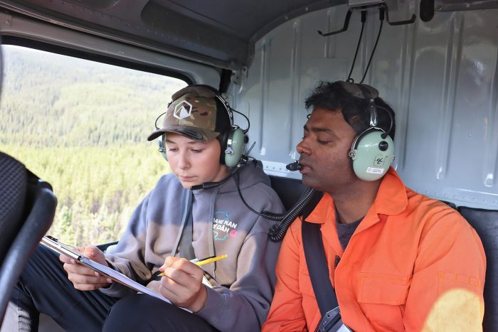
Kaska Land Guardian Daniel Koehl and DUC’s James Varghese record wetland information during a helicopter survey. Photo © DUC
Investing in Indigenous Guardians
In August, Environment and Climate Change Canada announced nearly $30 million in funding for more than 80 First Nations, Inuit and Métis Guardians initiatives across the country. These initiatives to address the twin crises of climate change and biodiversity loss are taking place from coast to coast to coast, providing benefits for Indigenous communities, the natural environment, and species at risk, including boreal caribou.
DUC is pleased to see that Indigenous-led conservation has been recognized as a vital part of Canada’s strategy to protect nature and achieve its biodiversity goals. We believe Indigenous-led conservation is essential to drive the kind of large, landscape-level change that’s required to create a healthy and sustainable future.
DUC greatly values our partnerships with Indigenous communities and governments and we support Indigenous Guardians programs across Canada. We look forward to the continued braiding of our knowledge systems to advance shared conservation goals.
What’s an Indigenous Protected and Conserved Area (IPCA)?
An IPCA has three main characteristics:
- They are Indigenous led. One or more Indigenous communities can have sole governance over an area, or in some cases partnerships exist between Indigenous and government, Indigenous and non-government organizations, or a hybrid model. In all cases, Indigenous leadership is paramount.
- They represent a long-term commitment to conservation. IPCAs empower Indigenous stewardship models, promote healthy ecosystems and ensure the conservation of lands and waters for future generations.
- They elevate Indigenous rights and responsibilities. Indigenous Peoples have long-standing physical and spiritual relationships with lands and waters. Local leaders work with their communities on how to use the land and water to aid conservation and cultural objectives.
Want to learn more? The new IPCA Knowledge Basket is a digital space that holds collections of resources honouring, celebrating and catalyzing Indigenous-led conservation pathways in Canada. Explore your basket and join in learning at ipcaknowledgebasket.ca.
Banner image: Ducks Unlimited Canada and Dane nan yé dāh Kaska Land Guardians surveying roadside wetlands. Photo © DUC